

459 résultats
Exporter les résultats sélectionnés
Sélectionner tous les résultats de la page
-
Notice détaillée
Titre :
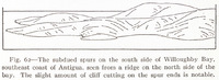
Fig. 62 — The subdued spurs on the south side of Willoughby Bay, southeast coast of Antigua, seen from a ridge on the north side of the bay. The slight amount of cliff cutting on the spur ends is notable.
Extrait de :
The Lesser Antilles
Type :
Image - Dessin, estampe, peinture
Description :
Dessin des éperons sur la côte sud de la Baie de Willoughby
Conditions d'utilisation :
Domaine public

-
Notice détaillée
Titre :
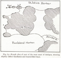
Fig. 63 — Rough plan of part of the west coast of Antigua, showing slightly cliffed headlands and beach-filled bays.
Extrait de :
The Lesser Antilles
Type :
Image - Carte, plan
Description :
Dessin d'un plan sommaire de la côte ouest d'Antigua
Conditions d'utilisation :
Domaine public
-
Notice détaillée
Titre :
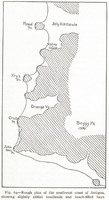
Fig. 64 — Rough plan of the southwest coast of Antigua, showing slightly cliffed headlands and beach-filled bays.
Extrait de :
The Lesser Antilles
Type :
Image - Carte, plan
Description :
Desin d'un plan sommaire de la côte ouest d'Antigua
Conditions d'utilisation :
Domaine public
-
Notice détaillée
Titre :
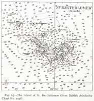
Fig. 65 — The Island of St. Bartholomew (from British Admiralty Chart No. 2038).
Extrait de :
The Lesser Antilles
Type :
Image - Carte, plan
Description :
Carte topographique de l'île de Saint Barthélémy
Conditions d'utilisation :
Domaine public
-
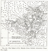
Notice détaillée
Titre :
Fig. 66 — The Island of St. Martin (from British Admiralty Chart No. 2038).
Extrait de :
The Lesser Antilles
Type :
Image - Carte, plan
Description :
Carte topographique de l'île de Saint Martin
Conditions d'utilisation :
Domaine public
-
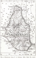
Notice détaillée
Titre :
Fig. 7 — Montserrat (from U. S. Hydrogr. Office Chart No. 1011).
Extrait de :
The Lesser Antilles
Type :
Image - Carte, plan
Description :
Carte topographique de l'île de Montserrat
Conditions d'utilisation :
Domaine public
-
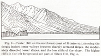
Notice détaillée
Titre :
Fig. 8 — Center Hill, on the northwest coast of Montserrat, showing the deeply incised inner valleys between sharply serrated ridges, the moderately dissected lower slopes, and the low cliffs of the shore. The higher cliffs in the left foreground are part of Silver Hill, Fig. 6.
Extrait de :
The Lesser Antilles
Type :
Image - Dessin, estampe, peinture
Description :
Dessin de Center Hill, sur la côte nord ouest de Montserrat montrant des plateaux profondéments incisés
Conditions d'utilisation :
Domaine public
-
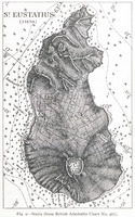
Notice détaillée
Titre :
Fig. 9 — Statia (from British Admiralty Chart No. 487).
Extrait de :
The Lesser Antilles
Type :
Image - Carte, plan
Description :
Dessin de l'île de Statia
Conditions d'utilisation :
Domaine public
-
Notice détaillée
Titre :
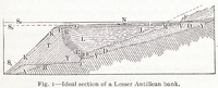
Fig. I — Ideal section of a Lesser Antillean bank
Extrait de :
The Lesser Antilles
Type :
Image - Dessin, estampe, peinture
Conditions d'utilisation :
Domaine public
-
Notice détaillée
Titre :
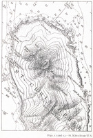
Figs. 12 and 13 — St. Kitts (from U.S.
Extrait de :
The Lesser Antilles
Type :
Image - Carte, plan
Description :
Carte topographique de Saint Kitts
Conditions d'utilisation :
Domaine public
